
Insurance & Flood Maps After the January Storms: Ventura vs LA (What Buyers & Sellers Must Know About Flood Insurance 2026)
The storms were real, the flooding was uneven, and the transaction impacts are immediate. Use this post-storm guide to verify zones, anticipate remapping, and avoid last-minute lender or underwriting surprises—without fear-mongering.

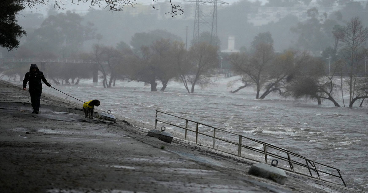
In January 2026, a major atmospheric river event hit Southern California and pushed flood risk from “background issue” to “transaction issue.” That matters because flood risk can affect lender conditions, insurance pricing, and closing timelines even when the home looks perfectly fine on a sunny day. The fastest, most defensible way to start is by pulling the official map panel for the address and saving it to your escrow file. Then, layer in what actually happened during the storms (drainage failures, creek overflows, debris flow corridors) to understand why underwriters may be stricter in certain neighborhoods.
Outbound tools: FEMA Flood Map Service Center • California Department of Water Resources
If you’re buying, selling, or already in escrow, this is the flood insurance 2026 playbook you want to follow from Day 1. In the weeks after the storms, flood insurance 2026 decisions can determine whether a deal closes cleanly or gets slowed by lender conditions and underwriting questions. This guide is built for Ventura County and Los Angeles County transactions where timing matters: you’ll learn how to check FEMA flood maps, how to interpret the zones that lenders care about, how post-storm “preliminary remapping” can influence insurance even before maps go official, and what documentation to gather early so your escrow doesn’t get stuck at the finish line. If you also need the wildfire-side insurance strategy, you’ll want the companion resource here: Home insurance guide (FAIR Plan + DIC).
Flood Insurance 2026: What Happened in January & Why It Changed Everything
First, the storm sequence wasn’t a normal “rainy weekend”—it was a major atmospheric river event from January 10–15, 2026 that delivered roughly 8–12 inches
of rain in about 72 hours across parts of Ventura County and Los Angeles County. Next, the flooding pattern was highly localized, which is exactly why buyers
and sellers are getting confused: one street can look untouched while the next corridor sees overflow, pooling, and repeated drainage backups. Meanwhile, Ventura
River conditions escalated quickly and created flooding concerns in and around Ventura (including corridor-adjacent pockets that feel the effects when flows rise
and soils saturate). Additionally, multiple areas in Oxnard and Camarillo experienced overwhelmed storm drains, especially where runoff concentrates toward low points
or where outfalls struggle during peak intensity. Similarly, parts of Thousand Oaks saw localized impacts near wash systems and channels (including sections near Arroyo
Conejo), where saturated ground and fast runoff can expose weaknesses in drainage infrastructure.
However, Los Angeles County had its own set of stress points: Malibu Creek and Topanga Creek surged, and sections of the Tujunga Wash system overflowed or backed up
during peak intensity. Likewise, the San Fernando Valley saw low-lying pockets in Studio City, Sherman Oaks, and West Hills affected in ways that homeowners rarely
plan for—especially when water moves faster than storm drain capacity. Consequently, flood risk moved from “rare possibility” to “recent precedent,” which is a major
underwriting signal. Moreover, FEMA began a preliminary remapping assessment on January 20, 2026, and while final map changes can take time, the transaction reality
is immediate: lenders still rely on effective maps for mandatory purchase rules, but insurers can price and underwrite based on observed risk, local studies, and
corridor-specific loss experience. Finally, the estimated timeline for updated flood maps to be finalized is commonly 6–12 months, and that transition period is where
the confusion lives—because the official map may lag behind what people saw with their own eyes.
Flood coverage is separate from homeowners insurance and separate from wildfire coverage strategy. If you’re also navigating wildfire-side insurance, use the companion resource: Home insurance 2026 guide (FAIR + DIC).
Transaction tip: if you’re budgeting overall deal feasibility, don’t isolate flood costs from the rest of the purchase math. Instead, pair your insurance quote timing with cash-to-close planning using closing cost examples, and verify affordability boundaries if you’re near the conforming/jumbo line with 2026 loan limits (Ventura vs LA).
How to Read FEMA Flood Maps & Check Your Property's Zone (2026 Updates)
However, the single most useful thing you can do is learn what the zone letters actually mean for transactions. Zone A is a high-risk flood area (the 1% annual chance,
often called the “100-year floodplain”), and it typically does not show base flood elevations on the panel. Similarly, Zone AE is also high-risk, but it includes base flood
elevations, which can matter for rating, underwriting decisions, and whether elevation documentation may reduce premiums. Additionally, Zone AH indicates shallow flooding
(often 1–3 feet) with base flood elevations shown, while Zone AO typically reflects sheet-flow flooding where water spreads across a broad area rather than staying in a single
defined channel. Meanwhile, Zone X (shaded) is moderate risk (commonly tied to the 0.2% annual chance or “500-year floodplain”), and Zone X (unshaded) is minimal mapped risk,
outside the 500-year floodplain. Consequently, “X” does not mean “no flood risk”—it means “not in the primary mapped high-risk corridor,” which is an important distinction
after an extreme storm.
Moreover, the FEMA Map Service Center is your baseline verification tool because it ties an address to an official panel and effective date. That’s crucial: in real estate,
lenders generally reference effective maps to determine mandatory purchase requirements, while insurers can incorporate additional information to set price and terms. Next,
preliminary maps matter because they can change underwriting behavior before the effective map changes—especially in corridors that experienced documented flooding, drainage failures,
or repeated claims. Likewise, “preliminary” does not automatically create a lender mandate, but it can change the conversation: buyers start asking for quotes earlier, sellers get
more disclosure questions, and some insurers require more documentation before binding a policy. Finally, your goal isn’t to become a cartographer; it’s to create a simple file that
supports escrow: (1) the FEMA panel screenshot or PDF, (2) the zone determination, (3) any elevation certificate if available, and (4) a quote timeline that matches your closing.
- Open the official tool: FEMA Flood Map Service Center.
- Search the address, open the FIRM panel, and note the effective date.
- Confirm the zone (A, AE, AH, AO, X shaded, X unshaded) and save it to your escrow file.
If you want market context while you choose neighborhoods, use the hubs that track inventory and leverage: Ventura County market updates and San Fernando Valley market updates. Insurance is a budget line item, but market pressure determines whether you can negotiate repairs, credits, or concessions.
Flood Insurance 2026 in Ventura County: Post-Storm Areas of Concern
| City / Area | Post-storm concern | Typical FEMA zone signals | Transaction takeaway |
|---|---|---|---|
| Ventura (Ventura River corridor, Main Street, Westside) | River rise + saturated ground near corridor | A / AE pockets near channel; nearby X (shaded) | Verify zone early; ask about elevation docs |
| Oxnard (Ormond Beach, Channel Islands Harbor, storm drain zones) | Drain overload + coastal low-lying grid | X (shaded) patterns; coastal exposure varies | Quote during escrow; confirm lender triggers |
| Camarillo (Calleguas Creek areas) | Creek-adjacent surge and runoff concentration | AE/A near creek; mixed X nearby | Map + inspection alignment matters |
| Thousand Oaks (Arroyo Conejo proximity) | Wash behavior + localized drainage failures | X (shaded) near washes; occasional A/AE nodes | Don’t assume “no zone = no risk” |
| Fillmore (Santa Clara River proximity) | River proximity + fast runoff after saturation | A/AE corridors near river | Elevation + policy timing are critical |
| Port Hueneme (coastal low-lying areas) | Coastal flooding + drainage backup risk | Block-by-block variation | Get a bindable quote early |
Furthermore, Ventura County flood exposure tends to show up in repeatable patterns: river corridors, creek-adjacent blocks, coastal low-lying grids, and specific storm-drain
“collection points” where water pools when intensity outruns capacity. Next, Ventura (city) often centers around the Ventura River corridor, where the Main Street area and Westside
pockets can be sensitive when flows rise rapidly and saturated ground reduces absorption. Additionally, Oxnard’s storm impacts are frequently about drainage system stress: when storm
drains are overwhelmed, water seeks low points and can pool in ways that feel “random” to residents, even though the pattern is predictable at the neighborhood scale. Similarly, coastal
low-lying areas—especially near Ormond Beach, Channel Islands Harbor-adjacent corridors, and certain outfall zones—can experience backup behavior during peak intensity.
Meanwhile, Camarillo risk often clusters near Calleguas Creek influence areas, where runoff concentrates and high-intensity rainfall can translate into rapid rises. Likewise, Thousand Oaks
issues can appear near wash systems like Arroyo Conejo, where terrain funnels water and localized drainage can fail under extreme volume. Consequently, buyers who assume “I’m not right on
a river, so I’m fine” miss the practical risk: flooding can be driven by storm drain capacity, slope, and where the neighborhood collects runoff—not just by living on the water’s edge.
Moreover, Fillmore’s proximity to the Santa Clara River is a reminder that even inland corridors can face flood concerns after multi-day storms, especially when soils are already saturated.
Finally, your best strategy is to treat mapping like an offer deliverable: save the FEMA panel, ask targeted questions, and price the risk early so it doesn’t show up as a surprise later.
Use local data to support decisions, not assumptions. Pair the map check with pricing and negotiation context from Ventura market updates, run affordability boundaries using loan limits, and keep the budget grounded with closing cost examples.
If you’re evaluating multiple cities, it helps to anchor pricing with a baseline valuation tool: home value report. When buyers see risk, they negotiate; when sellers document, they reduce friction.
Flood Insurance 2026 in Los Angeles County: Post-Storm Areas of Concern
| City / Area | Post-storm concern | Typical FEMA zone signals | Transaction takeaway |
|---|---|---|---|
| Malibu (Malibu Creek, PCH corridor, Malibu Lagoon) | Creek surge + coastal interactions | A/AE near creek; coastal complexity varies | Quote early; expect underwriting review |
| Topanga Canyon (Topanga Creek) | Canyon drainage + debris flow pathways | AE/A nodes near creek; adjacent X (shaded) | Ask for elevation docs if available |
| Studio City (LA River / Tujunga Wash proximity) | Wash overflow + low-lying pockets | X (shaded) near wash; A/AE corridors nearby | Don’t delay quotes until late escrow |
| Sherman Oaks (low-lying areas near wash systems) | Drainage collection points + backflow potential | X (shaded) patterns; localized exposure | Budget premium scenarios early |
| West Hills (west valley drainage issues) | Surface runoff + constrained drainage | X zones with localized concerns | Verify map + underwriting trends |
| San Fernando (Pacoima Wash) | Wash proximity + overflow risk | A/AE corridors near wash | Confirm SFHA triggers with lender |
| Calabasas (Las Virgenes Creek) | Creek-adjacent surge patterns | AE/A pockets near creek; X nearby | Map + quote + disclosure alignment |
However, Los Angeles County flood exposure after the January storms is best understood as a mix of canyon systems, creek corridors, and engineered wash networks that can overflow
or back up during extreme intensity. Next, Malibu sits at the intersection of creek behavior and coastal conditions: Malibu Creek, the lagoon area, and segments along the PCH corridor
can see rapid changes when runoff spikes and drainage cannot keep up. Additionally, Topanga Canyon’s risk often includes debris flow pathways and canyon drainage constraints; even when a
property sits above the obvious creek line, water and debris can move through the landscape in ways that surprise buyers who only look at curb appeal.
Similarly, the San Fernando Valley’s flood story is not “one big floodplain”—it’s pockets and corridors near systems like Tujunga Wash, the LA River network, and local low points where
runoff concentrates. Consequently, Studio City and Sherman Oaks can see impacts in low-lying areas near wash systems, especially during peak intensity when storm drains are overwhelmed.
Moreover, West Hills can experience west valley drainage constraints where runoff moves quickly across surfaces and collects at predictable points. Likewise, San Fernando neighborhoods
near Pacoima Wash remind buyers that engineered channels and washes are part of the risk map—both literally and practically—after a large storm.
Finally, if you’re making a neighborhood decision in LA or the Valley, pair the flood due diligence with local market leverage: use the
San Fernando Valley market updates hub
to understand whether you can negotiate price, repairs, or credits when risk documentation raises questions.
For buyers who want a budget-first approach, run your baseline numbers with closing costs (Ventura vs LA examples) and confirm financing boundaries with 2026 conforming + jumbo limits. Then, add insurance quotes early so you’re not improvising at the end.
Flood Insurance 2026: When It's Required vs Recommended
Therefore, here’s the rule that matters in most escrows: if a property is in a Special Flood Hazard Area (SFHA)—commonly Zone A or Zone AE—and you’re using a federally backed mortgage,
flood insurance is generally required as a condition of the loan. Next, the recommended category is larger than most people expect: Zone X (shaded) properties, or homes just outside A/AE
corridors that experienced real-world flooding in January, can benefit from coverage or at least a quote so you can price the risk. Additionally, flood insurance is separate from homeowners
insurance; even a strong homeowners policy typically does not cover flood damage, which is why buyers are surprised after storm seasons.
Meanwhile, the National Flood Insurance Program (NFIP) is the baseline many people reference. NFIP building coverage is typically available up to $250,000 and contents up to $100,000, and it’s
separate from your homeowners policy. Likewise, NFIP commonly has a 30-day waiting period, with exceptions that may apply for certain purchase transactions—so timing matters. Consequently, getting a
quote during escrow is not optional if you want a predictable closing; it’s part of due diligence. Moreover, annual premiums commonly range from about $400 to $2,000+ depending on zone, elevation,
and other factors, and those costs should be incorporated into your monthly payment planning the same way you treat taxes, insurance, and HOA dues.
Finally, private flood insurance can be a viable alternative in some situations, sometimes offering higher limits or different terms and, in certain cases, potentially faster issuance. The right move is
to compare options early and align the policy with lender requirements, not just price.
“Required” usually means SFHA + federally backed loan rules. “Recommended” means protecting your budget and resale position when observed risk outpaces what the map implies.
Budgeting tip: incorporate the flood premium into your transaction math using closing cost planning, and keep the pricing context grounded with the Ventura market updates hub.
If You're Buying: Flood Insurance 2026 Due Diligence Checklist
Pull the FEMA panel and save it to your file. Then, align your offer timeline with lender and insurance timelines the same way you do with financing boundaries like conforming vs jumbo limits.
If it exists, it can help your insurer evaluate risk more precisely. Even without it, ask questions that clarify the property’s relationship to nearby channels, washes, or low points.
Treat the quote like appraisal timing: an early deliverable that prevents end-of-escrow chaos. Budget it with closing cost examples.
NFIP commonly has a 30-day waiting period, with exceptions that may apply in purchase transactions. Confirm timing early so it doesn’t become a last-week delay.
Premium ranges can materially change affordability. If you’re comparing neighborhoods, pair flood costs with local pricing pressure using Ventura updates and SFV updates.
If the neighborhood had visible flooding in January, request quotes earlier than you think you need—especially if your escrow is tight and lender conditions are strict.
If You're Selling: Flood Insurance 2026 Disclosure Requirements
Disclosures are about facts and documentation—not interpretations. If the property had water intrusion, pooling, drainage repairs, or a flood-related claim, expect buyers to ask for specifics.
What to disclose
- Any known flooding, seepage, or recurring pooling (even if it didn’t reach living areas).
- Drainage upgrades, grading work, sump pumps, or waterproofing actions completed after storms.
- Insurance claims related to water intrusion or flood events (if applicable).
- Any notices from local agencies or HOA related to storm impacts or drainage systems.
- Known proximity to creeks, rivers, washes, or identified low-lying corridors.
How to prepare documentation
- Pull the current FEMA map panel and keep it in your disclosure file.
- Collect receipts and permits for drainage or waterproofing work.
- Save before/after photos of mitigation or repair steps.
- Provide any elevation certificate on hand, if you have one.
- Pre-empt budget questions using closing cost examples.
Buyers handle uncertainty by requesting credits, delays, or walk-away rights. If you want smoother negotiations, package your map panel, documentation, and repairs clearly, then support pricing with local demand context from Ventura updates or SFV updates.
When Will New FEMA Maps Be Official? (2026-2027 Timeline)
First, understand the phases: preliminary assessments and advisory guidance can arrive before final maps, and those early steps can influence underwriting even when lenders still rely on the effective map. Next, the January 20, 2026 preliminary remapping assessment is best viewed as the start of data collection: field verification, hydrology review, and analysis of storm impacts by corridor. Meanwhile, preliminary maps may appear later in 2026 for certain areas, especially where repeated flooding or concentrated damage suggests the effective map may understate exposure. Consequently, the finalization window often runs 6–12 months (and can extend beyond that if the scope is broad or if appeals occur), which is why 2026–2027 is a realistic planning horizon. Finally, during the transition period, the effective map governs lender mandates, but insurers may price and underwrite using a blend of official zoning and observed risk.
Data collection begins (damage patterns, hydrology review, corridor checks). This is not the final map—it's the start of a process.
Some areas may see preliminary mapping or localized advisories that influence underwriting before any effective panel changes.
Final maps can take 6–12 months or longer depending on scope, validation, and appeals. Plan for uncertainty in the interim.
Save the current FEMA panel for your address, re-check it if public notices appear, and ask your insurance professional how they’re treating post-storm corridors. If you’re also planning financing, keep your numbers aligned with loan limits and your budget aligned with closing cost planning.
FAQ: Flood Insurance 2026, FEMA Maps & Post-Storm Requirements
First, how do I know my property’s flood zone?
Use the FEMA Map Service Center address search, open the FIRM panel, confirm the zone and effective date, and save the map to your escrow file.
Next, what zones typically trigger mandatory flood insurance for loans?
In many cases, Zone A or Zone AE (SFHA) with a federally backed mortgage triggers a lender requirement. Confirm specifics with your lender early.
Then, does “Zone X” mean I don’t need to worry?
No. Zone X shaded is moderate risk and Zone X unshaded is minimal mapped risk, but drainage failures and runoff can still cause damage—especially after extreme storms.
After that, what’s the NFIP waiting period and can it delay closing?
NFIP policies often have a 30-day waiting period, with exceptions that may apply to purchase transactions. Confirm early so it doesn’t create a late escrow delay.
Also, how do NFIP coverage limits work?
NFIP building coverage is typically up to $250,000 and contents coverage up to $100,000. Higher-limit needs may require private flood options.
Moreover, can sellers reduce buyer concern after flooding season?
Yes: document repairs, share receipts, provide a clear map panel, and disclose factual history. Clean files reduce negotiation friction.
Finally, what’s the best way to budget for flood insurance?
Get quotes early, compare NFIP and private options, and incorporate premiums into monthly payment planning along with taxes, HOA, and other costs.
For NFIP basics, coverage definitions, and consumer guidance, see the National Flood Insurance Program.
Related Real Estate & Insurance Tools
- All Posts
- Buyer Guides
- California Home Insurance & Wildfire Risk
- Home Financing (Mortgage & Loan Guides)
- Market Updates & Forecasts
- Seller Guides
- Back
- Ventura County Real Estate Market Updates
- San Fernando Valley Real Estate Market Updates (Monthly): Prices, Inventory & Trends

Ventura County Mortgage Update “` Ventura County Mortgage Rates: What the Fed’s July 2026 Decision Means for Buyers A practical...

Median Home Price in Moorpark, CA (2026) Moorpark Housing Market 2026 Median Home Price in Moorpark, CA (2026): What Real...

Can ChatGPT sell your house in 2026? Here's what AI does well, where it falls short, and what it can...
Oxnard’s median home price is $785,000 in 2026, but prices vary sharply by zip code, property type, and neighborhood. See...

Oxnard’s median home price is $785,000 in 2026, but prices vary significantly by zip code and property type. Explore real...
See June 2026 Westlake Village home prices, days on market, and sales trends, plus what current conditions mean for local...